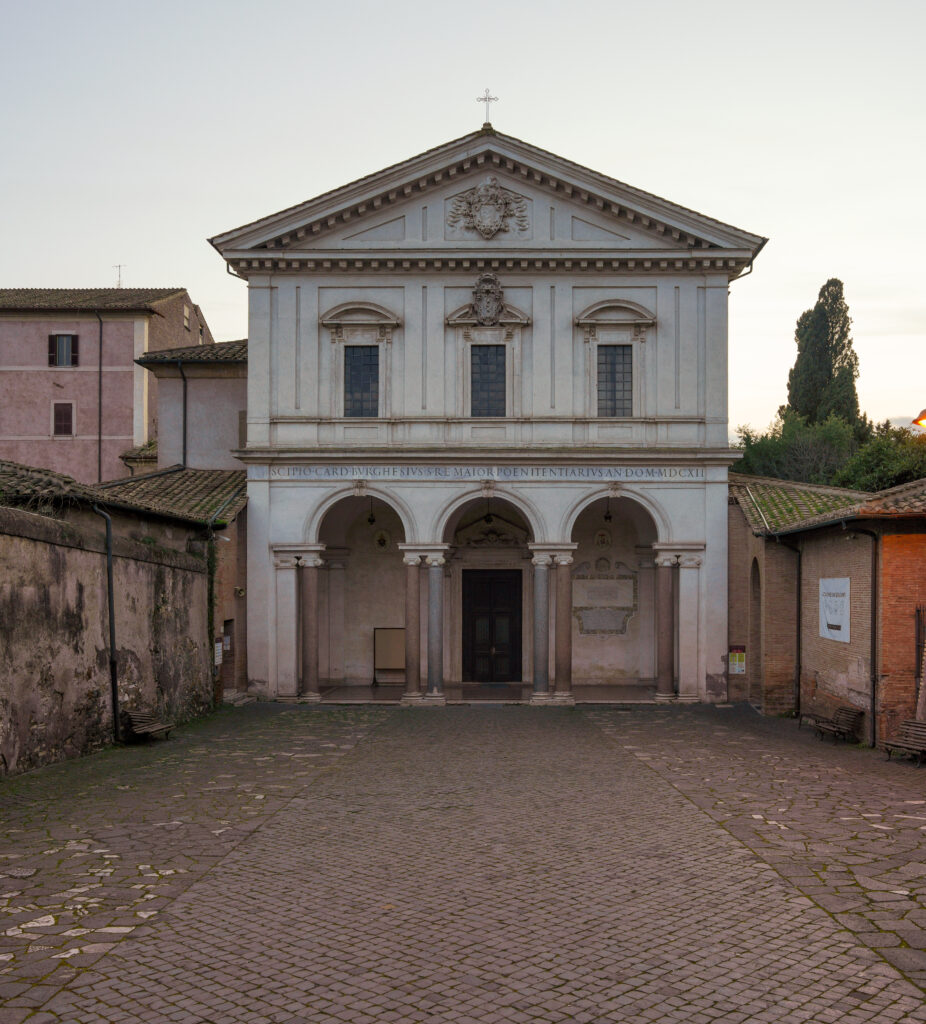
The Appian Way, also known as Via Appia in Latin and Italian, is one of the earliest and most strategically significant Roman roads of the ancient republic, connecting Rome to Brindisi in southeast Italy. Its significance is emphasized by its nickname, “Appia longarum regina viarum” (the queen of long roads), as recorded by Statius.
The road was named after Appius Claudius Caecus, the Roman censor who initiated and finished the first section as a military road to the south during the Samnite Wars in 312 BC.
Origins
The need for roads
The Appian Way served as a crucial route for military supplies during Rome’s conquest of southern Italy in 312 BC and for facilitating communication improvements, as evidenced by historical records.
As the first long road built specifically for transporting troops outside of the smaller region of greater Rome, the Appian Way was essential to the Romans. Prior to its construction, the few roads outside the early city were primarily Etruscan and mainly led to Etruria. However, by the late Republic, the Romans had expanded their reach over most of Italy and become skilled in road construction. Their roads originated from Rome, where the master itinerarium or list of destinations along the roads was located, and extended to the borders of their domain, leading to the well-known expression, “All roads lead to Rome”.
The Samnite Wars
The Romans had a connection with the people of Campania, who, like them, could trace their ancestry back to the Etruscans. The Samnite Wars were provoked by the Samnites when Rome tried to ally with the city of Capua in Campania. The Italic speakers in Latium had already been conquered and incorporated into the Roman state, resulting in Rome’s transformation from a primarily Etruscan to a primarily Italic society.
Despite this, there were still densely populated communities of independent Samnites in the mountains north of Capua, which is located just north of the Greek city of Neapolis. In approximately 343 BC, Rome and Capua attempted to establish an alliance, but the Samnites responded with military aggression.
The barrier of the Pontine Marshes
The area between Capua and Rome was occupied by the Pontine Marshes, also known as Pomptinae paludes, a swamp teeming with malaria. A meandering coastal road snaked between Ostia, located at the mouth of the Tiber, and Neapolis. The Via Latina, which follows a similarly challenging route, runs along the foothills of Monti Laziali and Monti Lepini, visible as towering over the former marsh.
During the First Samnite War (343-341 BC), the Romans discovered that they could not sustain or replenish their troops in the field against the Samnites over the marsh. A rebellion by the Latin League further depleted their resources, prompting them to abandon their attempted alliance and settle with Samnium.
Colonization to the southeast
The Romans were merely waiting for a solution while they sought ways to resolve the issue. Their first plan was the establishment of a “cultivation” of settlers from Rome known as the colonia, which would provide a permanent base of operations. The Second Samnite War (327-304 BC) began when Rome attempted to establish a colony at Cales in 334 BC and again at Fregellae in 328 BC on the opposite side of the marshes. The Samnites, now a major power after defeating the Greeks of Tarentum, took over Neapolis to secure its loyalty. The Neapolitans appealed to Rome, which responded by sending an army to drive out the Samnites from Neapolis.
Appius Claudius’ beginning of the works
In 312 BC, Appius Claudius Caecus was appointed censor in Rome. He belonged to the patrician gens Claudia, which traced its origins to the Sabines who were assimilated into the early Roman state. He was named after the gens’ founding ancestor, Appius Claudius (Attus Clausus in Sabine), and was known for his advocacy for the common people. Despite being a man of keen insight, he was said to have lost his sight during his years of success, earning him the moniker “caecus,” meaning “blind.”

Taking the initiative without waiting for the Senate’s direction, Appius Claudius launched ambitious public works projects to tackle the supply problem. One of these was the Aqua Appia, an aqueduct that secured Rome’s water supply. The most famous of his undertakings was the road, which traversed the Pontine Marshes to the northwest coast of Naples before heading north towards Capua. This road allowed fresh troops to be swiftly dispatched to the battlefield and supplies to be transported en masse to Roman bases without impediment from either the enemy or the terrain. It is no surprise that Appius Claudius went on to serve as consul twice and held various other offices, earning the state’s respect even in his later years as a valued advisor.
The success of the road
The road fulfilled its intended purpose as the outcome of the Second Samnite War finally favored Rome. Through a series of decisive victories, the Romans turned the tide of the war, compelling Etruria to come to the negotiating table in 311 BC, the same year as their rebellion, and Samnium in 304 BC. The road played a vital role in enabling them to mobilize their troops swiftly and to maintain their provisions, transforming them into a formidable adversary.
Construction of the road
Construction of the primary section of the Appian Way commenced in 312 BC and was completed in the same year.
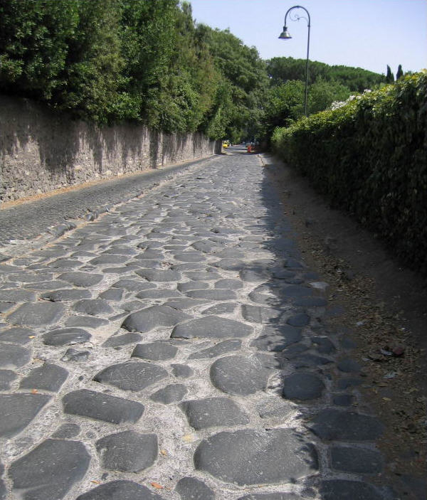
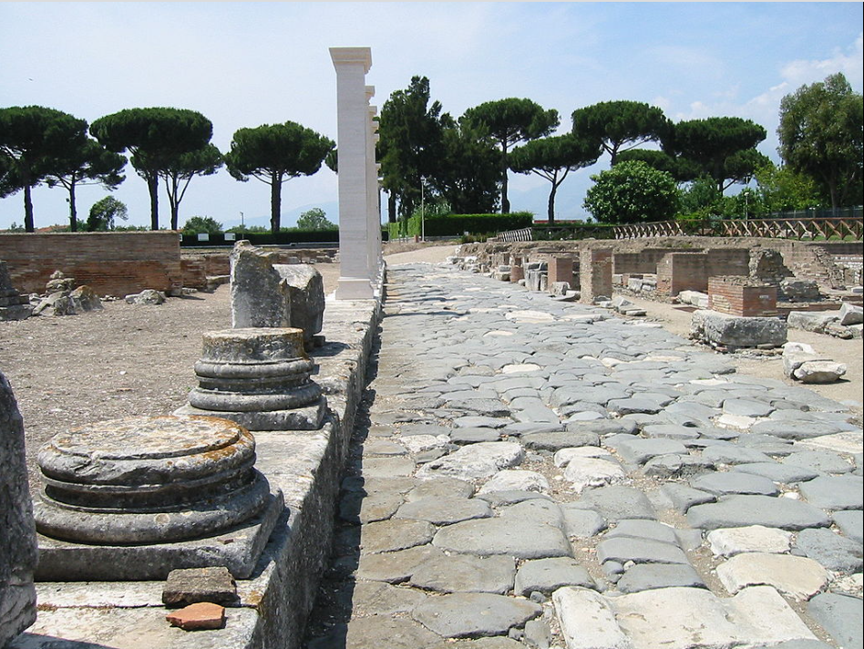
Initially, the road was built as a leveled dirt track, which was subsequently reinforced with small stones and mortar. Gravel was then added as an additional layer, followed by tightly interlocking stones that created a smooth and seamless surface. Procopius, the historian, noted that the stones fit so snugly that they seemed to have grown together, rather than being pieced together. The road had a middle section that sloped slightly downward for water runoff, with ditches on either side, which were shielded by retaining walls.
Between Rome and Lake Albano
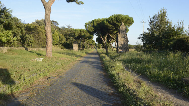
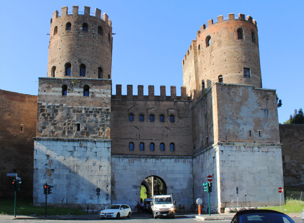
The Appian Way originated at the Forum Romanum, crossed the Servian Wall through the porta Capena, traversed a cutting in the clivus Martis, and exited the city. For this section of the road, the builders utilized the Via Latina. When the Aurelian Wall was constructed centuries later, another gate, the Porta Appia, was added. Beyond Rome, the new Via Appia traversed prosperous suburbs along the Via Norba, an ancient trail leading to the Alban hills, where Norba was located. The initial version of the road was a via glarea, or gravel road.
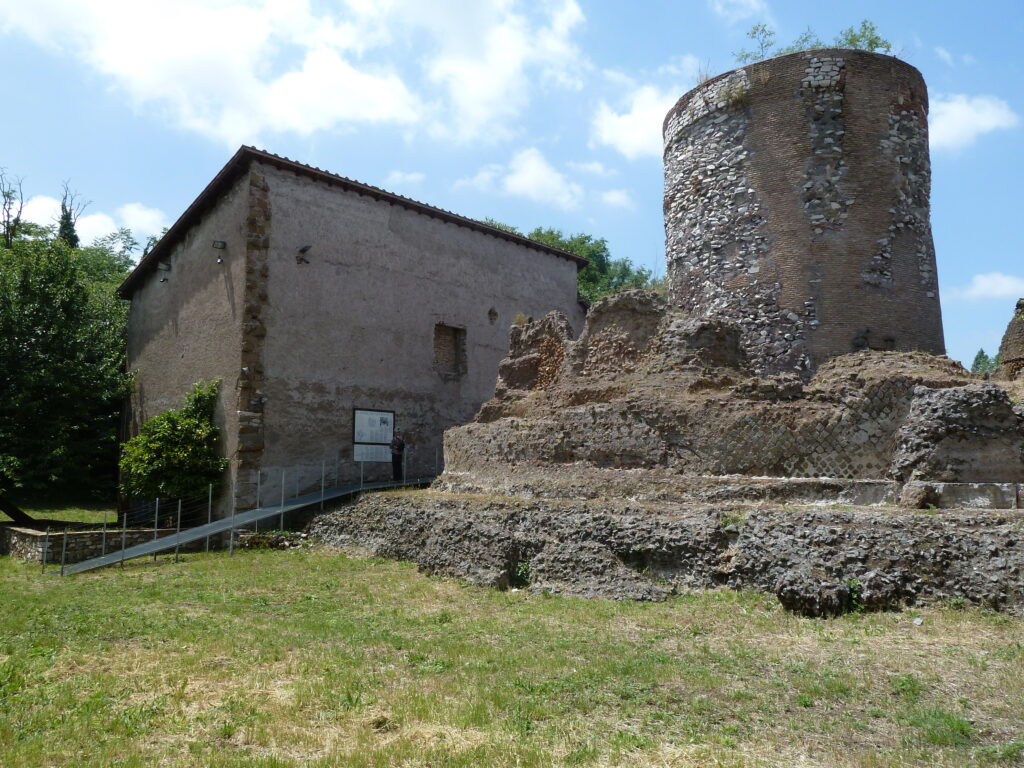
The Romans created a high-quality thoroughfare, consisting of layers of cemented stone atop a base of small stones, cambered to facilitate water drainage, with ditches on either side, low retaining walls in sunken portions, and dirt paths serving as sidewalks. It is believed that the Via Appia was the first Roman road to employ lime cement. The materials used were volcanic rock, and the surface was so smooth that the joints were indistinguishable. While the Roman portion of the road still exists, monuments from all eras now line it, and the cement has worn out of the joints, leaving behind a rugged surface.
Across the marsh
The road cuts straight through the Alban hills without yielding to its terrain and has steep gradients before entering the former Pontine Marshes. The marshes were crossed by a stone causeway that spanned approximately 31 kilometers (19 mi) over stagnant and malodorous pools blocked from the sea by sand dunes. Appius Claudius had aimed to drain the marsh by reviving earlier attempts, but his efforts were unsuccessful, and subsequently, the causeway and its bridges required constant repairs. In 162 BC, Marcus Cornelius Cathegus had a canal built along the road to alleviate traffic and provide an alternate route when the road was undergoing repairs. Romans preferred utilizing the canal.
Along the coast
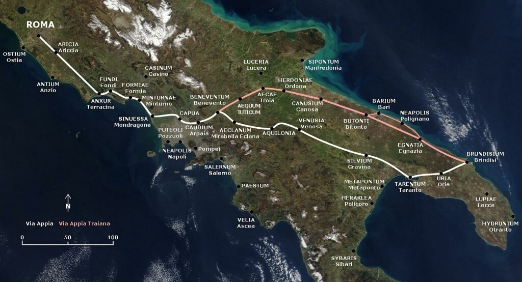
The Via Appia joined the coastal road at Tarracina (Terracina), where the Romans had made some cuttings to straighten it out, which now form cliffs. The road then turned northward towards Capua, where it ended at the time. The Caudine Forks were located just a short distance to the north. The itinerary included several towns such as Aricia (Ariccia), Tres Tabernae, Forum Appii, Tarracina, Fundi (Fondi), Formiae (Formia), Minturnae (Minturno), Suessa, Casilinum, and Capua, although some of these were added as colonies after the Samnite Wars. The total distance of the road was 212 kilometers (132 mi). The original road did not have milestones, as they were not yet in use, although a few milestones from later times remain, including the first one near the porta Appia.
Extension to Beneventum
The Third Samnite War (298–290 BC) may be considered misleadingly named, as it was actually an all-out attempt by all of Rome’s neighbors, including the Italics, Etruscans, and Gauls, to check Rome’s power. The Samnites were the leading people of the conspiracy. However, at the Battle of Sentinum in Umbria in 295 BC, Rome dealt a crushing blow to the northerners. Although the Samnites fought on alone, Rome established 13 colonies in Campania and Samnium. It was likely during this period that they extended the Via Appia an additional 35 miles beyond Capua, past the Caudine forks, to a place called Maloenton by the Samnites, which means “passage of the flocks”. The itinerary also included Calatia, Caudium, and Beneventum (not yet called by that name). This was also the endpoint of the Via Latina.
Extension to Apulia and Calabria
By 290 BC, the Samnites no longer held sovereignty and the Romans had access to the heel of Italy. While the dates during the Third Samnite War are uncertain, sources indicate that the Romans extended the Via Appia to Venusia, where they established a colony of 20,000 men. The city of Tarentum, the leading Greek city in southern Italy, was alarmed by Roman expansion and hired King Pyrrhus of Epirus to fight the Romans on their behalf. The Romans suffered a defeat at the Battle of Heraclea in 280 BC, prompting Pyrrhus to say “One more such victory and I am lost.”
After the battle, the Roman army turned on the Greek city of Rhegium and massacred Pyrrhian partisans. Pyrrhus decided to head straight for Rome along the Via Appia and then the Via Latina, knowing that he could be trapped in the marsh if he continued on the Via Appia. He withdrew without fighting after encountering opposition at Anagni. Pyrrhus won a costly victory at the Battle of Asculum in 279 BC, but was ultimately defeated by the Romans at the Battle of Beneventum in 275 BC. The Romans renamed the town from “Maleventum” to “Beneventum” as a result.
Pyrrhus withdrew to Greece, where he died in a street fight in Argos in 272 BC. Tarentum fell to the Romans that same year, and they consolidated their rule over all of Italy. The Romans extended the Via Appia to the port of Brundisium in 264 BC, with the itinerary from Beneventum being Venusia, Silvium, Tarentum, Uria and Brundisium. The Roman Republic became the government of Italy. Appius Claudius died in 273 BC, but his name remained associated with the Via Appia despite subsequent extensions.
Rediscovery
The path of the Appian Way across the regions of Lazio and Campania has always been well-known, but the exact location of the portion in Apulia was previously unknown due to the lack of visible remains. However, in the first half of the 20th century, the professor of ancient Roman topography, Giuseppe Lugli, used the innovative technique of photogrammetry to discover what was likely the route of the Appian Way from Gravina in Puglia (Silvium) up to Taranto. Through analysis of aerophotogrammetric shots of the area, Lugli identified a path known as la Tarantina, whose direction was influenced by the centuriation and thus, according to Lugli, was the path of the Appian Way. This path, including the section in Apulia, was still in use during the Middle Ages, and archaeological remains such as the ancient settlement of Jesce provided further evidence of Lugli’s proposed route.
Lugli also assigned the Appian Way stations Blera and Sublupatia, respectively, to the areas of Murgia Catena and Taverna (between the estate farmhouses of S. Filippo and S. Pietro) based on the distances given in the Antonine Itinerary. However, the toponym Murgia Catena was too vague to provide a clear localization of the Appian Way station. Recently, Luciano Piepoli suggested that Silvium should be Santo Staso, an area near Gravina in Puglia, Blera should be masseria Castello, and Sublupatia should be masseria Caione, based on the Antonine Itinerary’s distances and recent archaeological findings.
Extension by Trajan
The emperor Trajan constructed the Via Traiana, which was an expansion of the Via Appia starting from Beneventum and reaching Brundisium via Canusium and Barium, instead of Tarentum. To commemorate this, an arch was erected at Beneventum.
Travellers had the option to cross the Adriatic Sea through the Otranto Strait to Albania by disembarking either at present-day Durrës via the Via Egnatia or near the ancient town of Apollonia and continuing towards present-day Rrogozhina in central Albania.
Leave a Reply