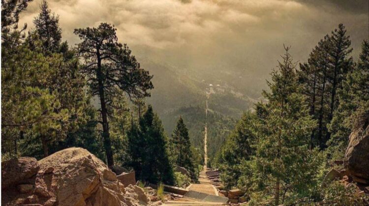
Manitou Incline
Often referred to as simply “The Incline,” this tourist cable car track turned heart-pounding workout is known for its rapid elevation gain, 2,768-step hiking trail, and sweeping views of Manitou Springs.
The Manitou Incline gains nearly 2,000 feet of elevation over less than 1 mile. It’s not for the faint of heart, but people from all walks (or climbs) of life have successfully conquered it. It is, perhaps, the most unique and challenging trail in the country, attracting runners, members of the military, Olympic athletes, and hiking enthusiasts from around the world.

More than anything, the Manitou Incline is famous for dishing out a tough workout.
Fast Facts
MANITOU INCLINE BY THE NUMBERS
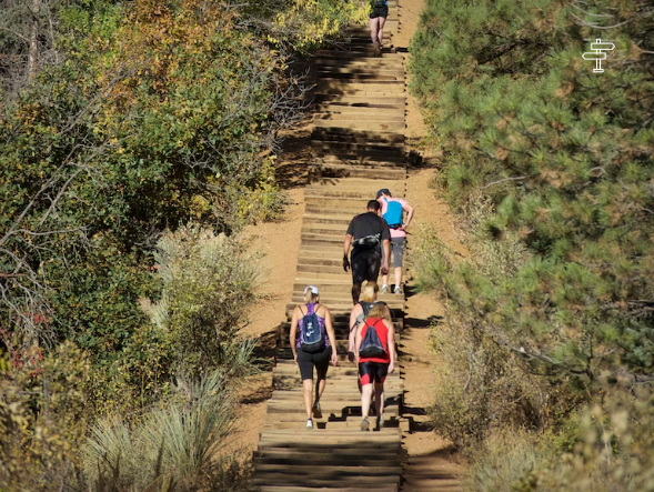
- 2,768 stairs
- 2,000 vertical feet of elevation gain
- 70,000+ visitors annually
- .88 miles
- 45% average grade
- 68% steepest grade
- Summit elevation of 8,500 feet
IMPORTANT RESERVATION INFORMATION
The Manitou Incline now utilizes a reservation system for all hikers. Incline users must make a free online reservation before hiking.
Manitou Incline Reservations, Regulations & Restrictions
As part of a memorandum of understanding between the cities of Colorado Springs and Manitou Springs, all Incline users must make a free online reservation before hiking and show proof of their reservation to an onsite attendant. The reservation and check-in system will be managed and staffed by the Colorado Springs Parks, Recreation and Cultural Services department.
BOOK RESERVATIONS NOW
THE RESERVATION PROCESS
- Reservations are available to be made 4 to 8 weeks in advance, however the reservation system will only show the current and next month.
- After making an online reservation at www.coloradosprings.gov/incline, users will receive a welcome email with directions for parking, rules and regulations.
- Paid parking is available at Hiawatha Gardens (10 Old Man’s Trail) at the Iron Springs Chateau (444 Ruxton Avenue).
- Those parking in the Hiawatha Gardens lot should plan for a 1.3–mile walk to the base of the Incline or utilize the free shuttle service.
- Plan ahead accordingly and arrive as close to your reserved time as possible.
- Upon checking in at the base of the Incline, hikers will be issued a wristband by an Incline attendant that must be worn at all times on the property.
- To cancel your reservation, please email your name and transaction ID to: [email protected]
HOURS & ADDITIONAL DETAILS
Winter reservations are available between 6 a.m. – 3 p.m. from November 6, 2023 through March 12, 2024. During the winter season, reservations are available for:
- 6:00-7:00 a.m. — 25 people per half hour
- 7:00-8:00 a.m. — 45 people per half hour
- 8:00 a.m. – 1:00 p.m. — 65 people per half hour
- 1:00-2:00 p.m. — 45 people per half hour
- 2:00-3:00 p.m. — 25 people per half hour
Summer reservations are available between 6 a.m. – 6:30 p.m. from March 13 through November 6, 2023. During the summer season, reservations are available for:
- 6:00-9:00 a.m. — 65 people per half hour
- 9:00 a.m. – 3:30 p.m. — 45 people per half hour
- 3:30-6:30 p.m. — 25 people per half hour
Access to the Manitou Incline is not permitted outside of the above posted hours.
Frequently Asked Questions
HOW MANY MILES IS THE MANITOU INCLINE?
The Incline is just under one mile in length.
HOW DIFFICULT IS THE TRAIL?
The trail is rated as difficult and recommended for physically active people and advanced hikers only. The Manitou Incline is not ADA accessible. Please be advised that it can take first responders up to 3-4 hours to reach you if you should have a medical issue on the trail.
HOW MANY STEPS ARE THERE ON MANITOU INCLINE?
Oh, just 2,768 steps – but who’s counting?
HOW STEEP IS THE INCLINE?
The Manitou Incline gains 2,000 feet in elevation from start to finish. The average grade for the trail is 45 percent and, in some places, it is as steep as 68 percent.
HOW LONG DOES IT TAKE TO CLIMB THE MANITOU INCLINE?
The average hiker completes the Manitou Incline hike in about 1-2 hours.
WHAT IS THE BEST TIME TO DO THE MANITOU INCLINE?
Hiking the Manitou Incline in the morning (the Incline opens at 6 a.m.) or later in the afternoon (the Incline closes at 6:30 p.m. in the summer, 3 p.m. in the winter) allows hikers to avoid hiking in the heat of the day, therefore reducing the risk of dehydration. For more tips for hiking the Incline, click here.
What is the history of the Manitou Incline?
The Manitou Incline was originally built as a cable car to carry materials to build pipelines on Pikes Peak – America’s Mountain. After the pipelines were finished, it was turned into a tourist attraction to bring guests to the top of the foothills for a spectacular view of Colorado Springs and the eastern plains.
A rock slide damaged a section of track in 1990, so the Manitou Springs Incline was closed down. The rails were removed, but the railroad ties remained in the form of a massive staircase. Locals started using it for a challenging workout. Until February 2013, a portion of it was private property and it was illegal to hike up the ties of the old cable car line. Now, due to cooperation among private and public entities, it is legal to climb the Incline. It is known as one of, if not the most, popular and challenging, hikes in the Colorado Springs area.
IS IT FREE TO HIKE THE MANITOU INCLINE?
Yes, the incline is FREE and open to the public. However, be sure and bring your wallet because you will have to pay for parking.
DO YOU NEED A RESERVATION?
Yes, all hikers must make a free reservation for the time you wish to start your climb. Click here to learn more about the Manitou Incline reservation system. Reservations are available 4 to 8 weeks in advance of your planned climb.
WHERE CAN I PARK?
Please park at one of the two locations designated for Incline Parking: the Hiawatha Gardens Parking Lot, located at 10 Old Man’s Trail or the Iron Springs Chateau, located at 444 Ruxton Ave. Both of these parking locations are paid.
There is a FREE shuttle that runs every 15 minutes from the Hiawatha Gardens Parking Lot to the Incline trailhead. You can plan ahead for parking and view how many open spaces are available on the City of Manitou Springs website.
Parking rates for the Hiawatha Gardens Lot change depending on the season. To view the current rates, please visit the City of Manitou Springs website.
HOW DO YOU GET BACK DOWN?
Once you’ve made it to the top – or rather if you make it to the top – you can hike down the bottom four miles of the Barr Trail. Downhill use of the Incline is strongly discouraged.
IS THERE A “BAILOUT” POINT?
Hikers who want a shorter loop or may have underestimated the difficulty of hiking the Incline can now hop off on the new Northern Incline Return Trail. This new trail will also be helpful for first responders in emergency situations and is the start of providing needed relief to the historic and heavily-trafficked Barr Trail. The Northern Incline Return Trail offers two new return options for hikers, both located in the bottom half of the Incline.
The first return is located at railroad tie #395 and the second is at #1300, the Inclines approximate midway point. From the new midway connection at tie #1300, located 500 stairs below the existing cut through to Barr Trail, hikers follow a new 1-mile, naturally-surfaced section to the existing Ute Pass Regional Trail. Once hikers reach Ute Pass, it’s roughly an additional half mile to the base of the Incline. From tie #395, there is 0.15 mile of new trail before connecting with Ute Pass for an additional 0.2-mile hike down to the trailhead.
WHAT IS THE FALSE SUMMIT?
Don’t be fooled by the false summit about three-quarters of the way up. At this point, the Manitou Incline intersects with Barr Trail and if you can’t make it to the top, then you can take that way back down if you’d like. After you crest the false summit, there are approximately 300 steps to go before you reach the top.
Leave a Reply