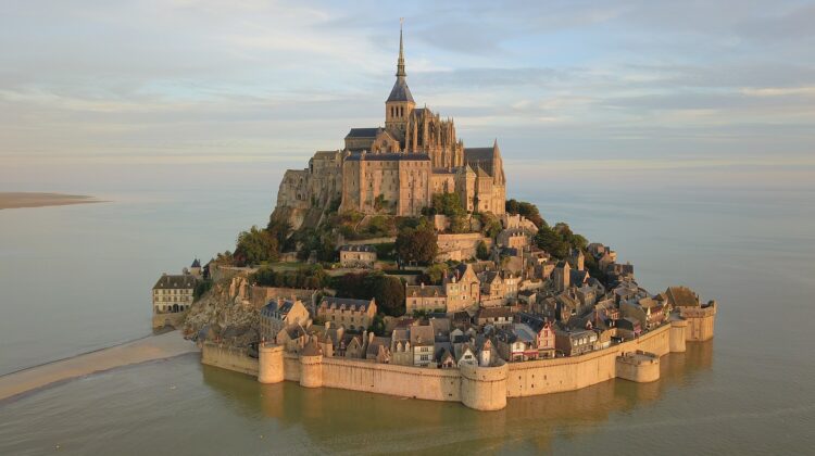
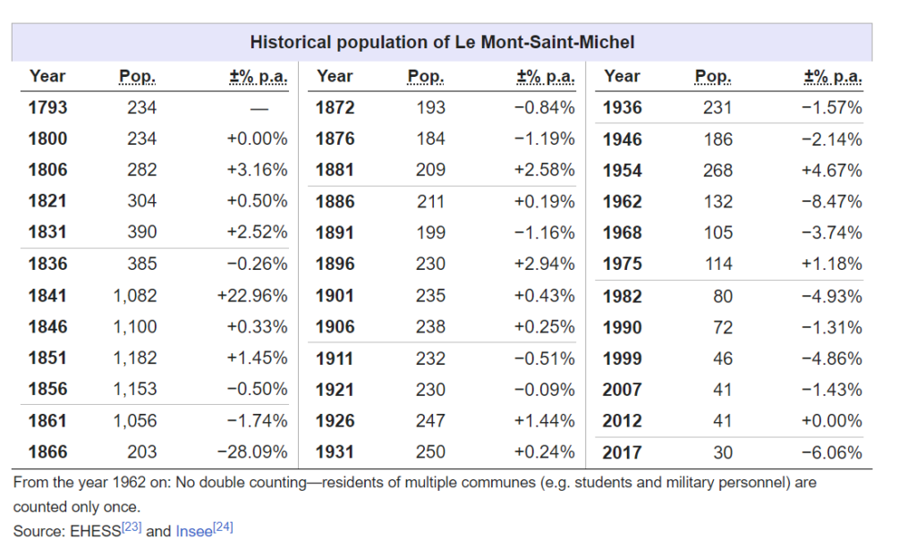
Mont-Saint-Michel (French pronunciation: [lə mɔ̃ sɛ̃ miʃɛl]; Norman: Mont Saint Miché; English: Saint Michael’s Mount) is a tidal island and mainland commune in Normandy, France. The island is located approximately one kilometre (one-half nautical mile) off the country’s north-western coast, at the mouth of the Couesnon River near Avranches, and covers an area of 7 hectares (17 acres). The mainland part of the commune covers an area of 393 hectares (971 acres), bringing the total surface area of the commune to 400 hectares (990 acres). As of 2019, the island had a population of 29.

By <a href=”//commons.wikimedia.org/wiki/User:Superbenjamin” title=”User:Superbenjamin”>Superbenjamin</a> – This file was derived from: <a href=”//commons.wikimedia.org/wiki/File:France_location_map-Regions_and_departements-2015.svg” title=”File:France location map-Regions and departements-2015.svg”>France location map-Regions and departements-2015.svg</a>, CC BY-SA 4.0, Link
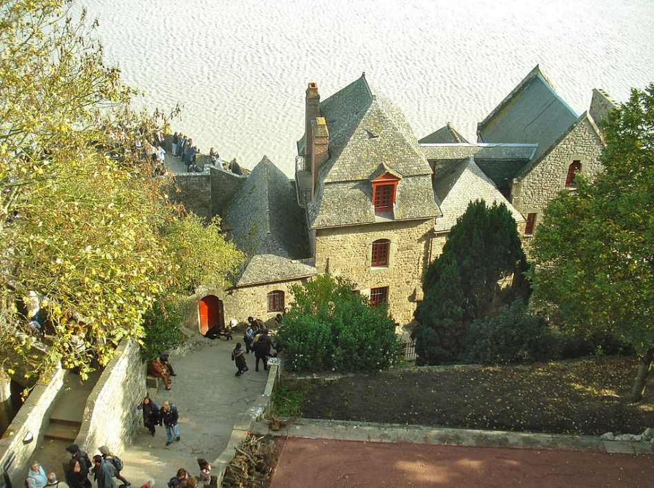
The commune’s location, on an island just a few hundred metres from the mainland, made it accessible at low tide to the many pilgrims visiting its abbey, but defensible as incoming tides would strand, drive off, or drown would-be assailants. The island remained unconquered during the Hundred Years’ War, with a small garrison successfully fending off a full attack by the English in 1433. Louis XI recognized the benefits of its natural defense and turned it into a prison. The abbey was regularly used as a prison during the Ancien Régime.
Mont-Saint-Michel and its surrounding bay were inscribed on the UNESCO list of World Heritage Sites in 1979 for their unique aesthetics and importance as a medieval Christian site. It is visited by more than three million people each year, and over 60 buildings within the commune are protected in France as monuments historiques.
Geography
Formation
Mont-Saint-Michel is a rocky tidal island that was once dry land during prehistoric times. However, as sea levels rose, erosion reshaped the coastal landscape, and several outcrops of granite emerged in the bay, including Lillemer, the Mont Dol, Tombelaine (the island just to the north), and Mont Tombe, which later became known as Mont-Saint-Michel.
Mont-Saint-Michel is primarily composed of leucogranite, which solidified from an underground intrusion of molten magma about 525 million years ago during the Cambrian period. It is one of the younger parts of the Mancellian granitic batholith. Early studies of Mont-Saint-Michel by French geologists sometimes described the leucogranite of the Mont as “granulite,” but this meaning of granulite is now obsolete.
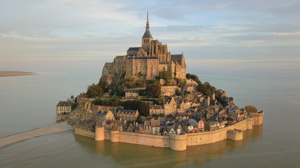
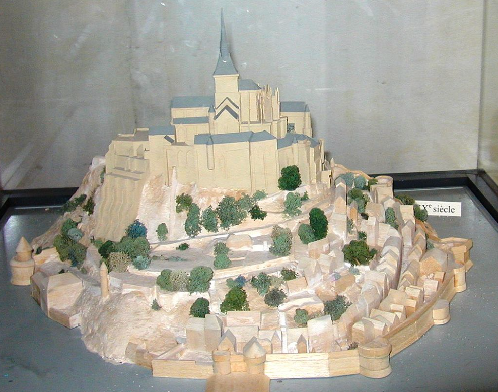
The Mont has a circumference of about 960 m (3,150 ft) and reaches a maximum height of 92 m (302 ft) above sea level.
Tides
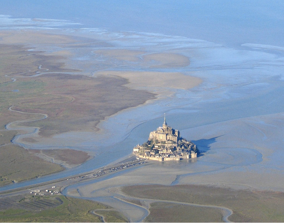
The tides at Mont-Saint-Michel vary greatly, with a difference of approximately 14 metres (46 ft) between the highest and lowest water marks. Medieval pilgrims making their way across the flats popularly nicknamed it “St. Michael in peril of the sea.” However, the mount can still be hazardous for visitors who avoid the causeway and attempt to walk across the sands from the neighboring coast.
Polderisation and occasional flooding have created salt marsh meadows that are ideally suited for grazing sheep. The well-flavored meat resulting from the diet of the sheep in the pré salé (salt meadow) is a local specialty known as agneau de pré-salé (salt meadow lamb). It can be found on the menus of restaurants that rely on income from the many visitors to the mount.
Tidal island
The connection between Mont-Saint-Michel and the mainland has changed over the centuries. Previously, it was connected by a tidal causeway uncovered only at low tide, which was converted into a raised causeway in 1879 to prevent the tide from scouring the silt around the mount. The coastal flats were also polderized to create pastureland, decreasing the distance between the shore and the island, and the Couesnon River was canalized, reducing the dispersion of the water flow. These factors have all encouraged silting-up of the bay.
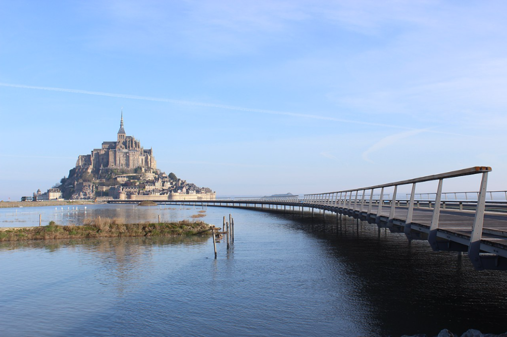
On 16 June 2006, the French prime minister and regional authorities announced a €200 million project (Projet Mont-Saint-Michel) to build a hydraulic dam using the waters of the Couesnon and the tides to help remove the accumulated silt and make Mont-Saint-Michel an island again. The construction of the dam began in 2009. The project also included the removal of the causeway and its visitor car park. Since 28 April 2012, the new car park on the mainland has been located 2.5 kilometres (1+1⁄2 mi) from the island. Visitors can walk or use shuttles to cross the causeway.
On 22 July 2014, a new bridge designed by architect Dietmar Feichtinger was opened to the public. The light bridge allows the waters to flow freely around the island and improves the efficiency of the now operational dam. The project, which cost €209 million, was officially opened by President François Hollande.
On rare occasions, tidal circumstances produce an extremely high “supertide.” The new bridge was completely submerged on 21 March 2015 by the highest sea level in 18 years, as crowds gathered to take photos.
History
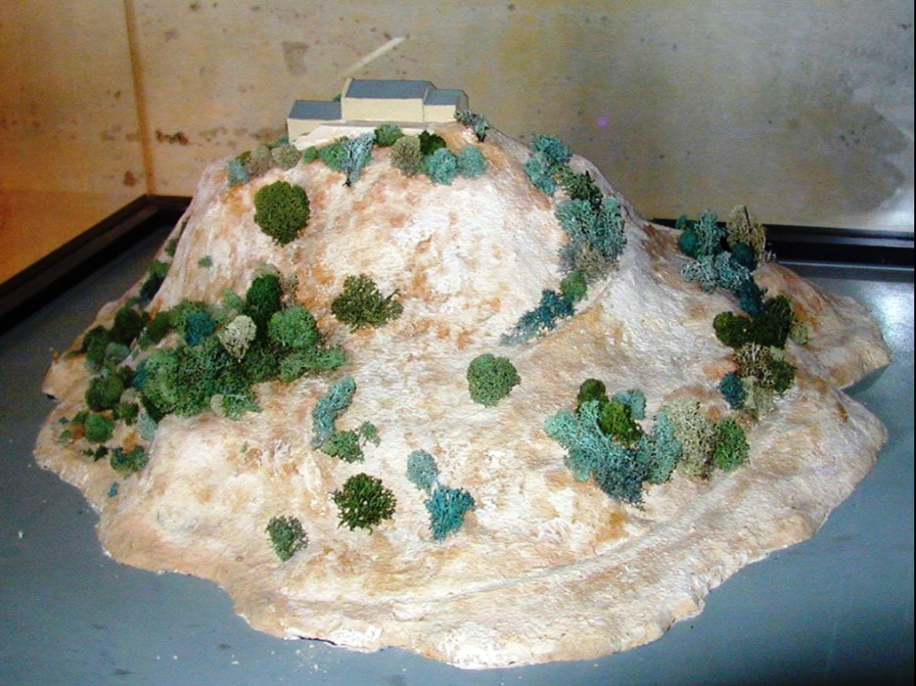
Before the construction of the first monastic establishment in the 8th century, the island was called Mont Tombe, Latin for “tomba.” According to legend, the archangel Michael appeared in 708 to Aubert of Avranches, the bishop of Avranches, and instructed him to build a church on the rocky islet.
Unable to defend his kingdom against the assaults of the Vikings, the king of the Franks agreed to grant the Cotentin peninsula and the Avranchin, including Mont-Saint-Michel, traditionally linked to the city of Avranches, to the Bretons in the Treaty of Compiègne. This marked the beginning of a brief period of Breton possession of the Mont. In fact, these lands, including Mont-Saint-Michel, were never really included in the duchy of Brittany. Around 989-90, these traditional bishoprics dependent on the archbishopric of Rouen, which had been left vacant during the Viking raids, regained their bishops.
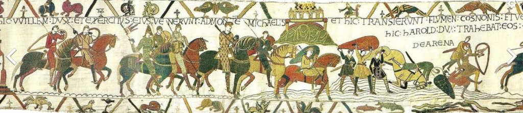
The mount gained strategic significance again in 933 when William I Longsword annexed the Cotentin Peninsula from the weakened Duchy of Brittany. This made the mount definitively part of Normandy, and it is depicted in the Bayeux Tapestry, which commemorates the 1066 Norman conquest of England. Harold Godwinson is pictured on the tapestry rescuing two Norman knights from the quicksand in the tidal flats during the conflict against Conan II, Duke of Brittany. Norman ducal patronage financed the spectacular Norman architecture of the abbey in subsequent centuries.
In 1067, the Mont-Saint-Michel monastery supported William the Conqueror in his claim to the throne of England. In return, he rewarded them with properties and grounds on the English side of the Channel, which included a small island off the southwestern coast of Cornwall. This island was modeled after the Mount and became a Norman priory named St Michael’s Mount of Penzance.
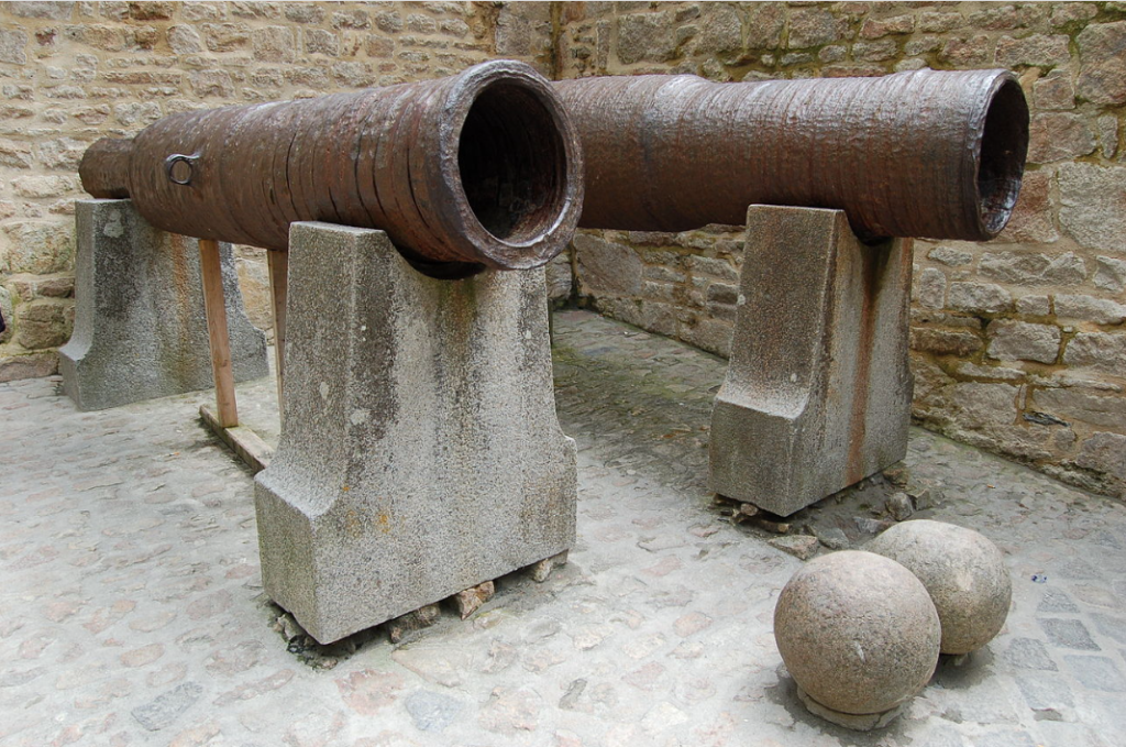
During the Hundred Years’ War, the Kingdom of England made repeated assaults on the island but was unable to seize it due to the abbey’s improved fortifications. The English initially besieged the Mont in 1423–24 and then again in 1433–34, with English forces under the command of Thomas de Scales, 7th Baron Scales. Two wrought-iron bombards that Scales abandoned when he gave up his siege are still on site and are known as les Michelettes.[19] Mont-Saint-Michel’s resolute resistance inspired the French, especially Joan of Arc.
When Louis XI of France founded the Order of Saint Michael in 1469, he intended for the abbey church of Mont-Saint-Michel to become the chapel for the order. However, because of its great distance from Paris, his intention could never be realized.
The wealth and influence of the abbey extended to many daughter foundations, including St. Michael’s Mount in Cornwall. However, its popularity and prestige as a center of pilgrimage waned with the Reformation, and by the time of the French Revolution, there were scarcely any monks in residence. The abbey was closed and converted into a prison, initially to hold clerical opponents of the republican regime. High-profile political prisoners followed, but by 1836, influential figures, including Victor Hugo, had launched a campaign to restore what was seen as a national architectural treasure. The prison was finally closed in 1863.
In 1872, the highly decorated French architect of historic monuments, Édouard Corroyer, was responsible for assessing the condition of the Mont. It took him about two years to convince his minister to classify Mont-Saint-Michel as a historic monument, and it was officially declared as such in 1874. From then on, this highly qualified and educated architect and member of the Academy of Fine Arts devoted himself entirely to the restoration of “la Merveille.” Under his direction, gigantic works were undertaken, starting with the most urgent, and he devoted fifteen years of his life to this work. He wrote four works on the building, and his name remains forever attached to the “resurrection” of Mont-Saint-Michel.
During the occupation of France in WWII, German soldiers occupied Mont-Saint-Michel, where they used St. Auburn church as a lookout post. The island was a major attraction for German tourists and soldiers, with around 325,000 German tourists visiting from July 18, 1940, to the end of the occupation of France. After the initial D-Day invasion by the Allies, many exhausted German soldiers retreated to strongholds like Mont-Saint-Michel. On August 1, 1944, Allied troops entered Mont-Saint-Michel. They were accompanied by two British reporters, Gault MacGowan of the New York Sun and Paul Holt with the London Daily Express, and crowds of jubilant French locals.
Mont-Saint-Michel and its bay were added to the UNESCO list of World Heritage Sites in 1979. It was listed with criteria such as cultural, historical, and architectural significance, as well as human-created and natural beauty.
Abbey design
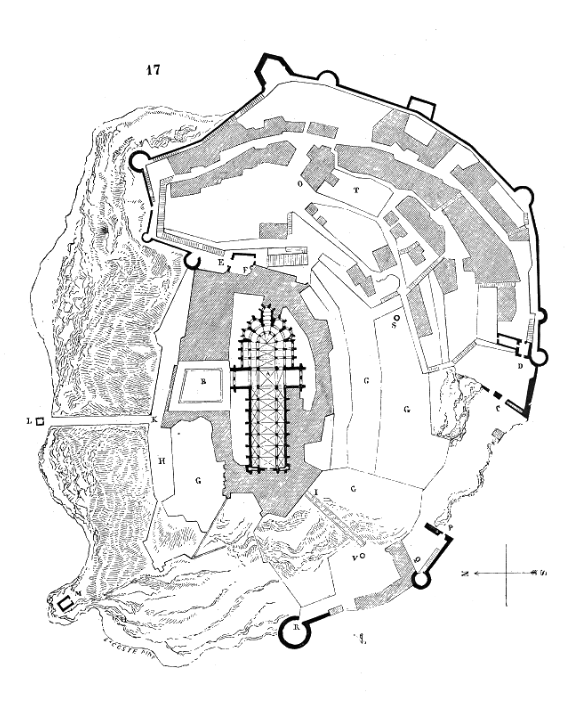
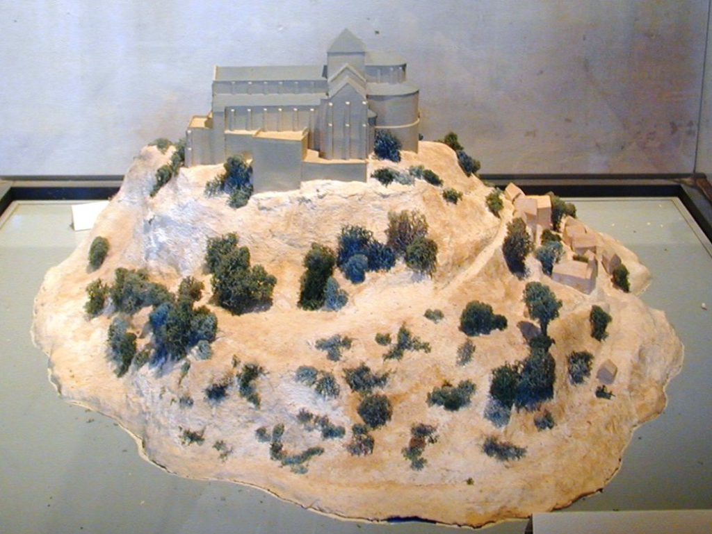
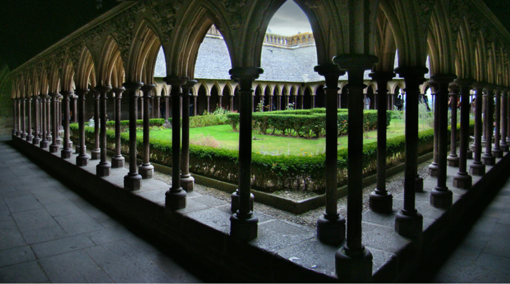
In the 11th century, Richard II, Duke of Normandy, chose William of Volpiano, the Italian architect who had built Fécamp Abbey in Normandy, to be the building contractor. He designed the Romanesque church of the abbey, daringly placing the transept crossing at the top of the mount. To compensate for this weight, many underground crypts and chapels had to be built, forming the basis for the supportive upward structure visible today. Mont-Saint-Michel is now considered a building of Romanesque architecture.
In the 12th century, Robert de Thorigny, a great supporter of Henry II of England (who was also Duke of Normandy), reinforced the structure of the buildings and built the main façade of the church. In 1204, as a vassal of the King of France, Guy of Thouars, regent for the Duchess of Brittany, undertook a siege of the Mount. After setting fire to the village and massacring the population, he was obliged to beat a retreat under the powerful walls of the abbey. Unfortunately, the fire that he started extended to the buildings, and the roofs were destroyed by the flames. Horrified by the cruelty and the exactions of his Breton ally, Philip Augustus offered Abbot Jordan a grant for the reconstruction of the abbey in the new Gothic architectural style.[21]
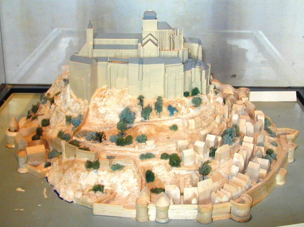
Charles VI is credited with adding significant fortifications to the abbey-mount, building towers, successive courtyards, and strengthening the ramparts.
Development
Administration
The islet belongs to the French commune of Le Mont-Saint-Michel, which is located in the département of Manche, in Normandy. The nearest significant town with an SNCF train station is Pontorson, which has a population of slightly over 4,000. Le Mont-Saint-Michel is a member of the Organization of World Heritage Cities.
Population
The Monastic Fraternities of Jerusalem
Since June 24, 2001, a community of monks and nuns from the Monastic Fraternities of Jerusalem, sent from the mother-house of St-Gervais-et-St-Protais in Paris, has been living as a community on Mont-Saint-Michel, following an appeal addressed to them in 2000 by Bishop Jacques Fihey, Bishop of Coutances and Avranches.[25] They replaced the Benedictine monks who returned to the Mount in 1966. The community consists of seven sisters and four brothers who live the mission that the Church has entrusted to them in their own charism of being “in the heart of the world” to be “in the heart of God”. Their life revolves around prayer, work, and fraternal life.[25] The community gathers four times a day to recite the liturgical office in the abbey itself (or in the crypt of Notre-Dame des Trente Cierges in winter). In this way, the building maintains its original purpose as a place of prayer and singing the glory of God. The community’s presence attracts many visitors and pilgrims who come to participate in the various liturgical celebrations.
In 2012, the community renovated a house on the Mount, the Logis Saint-Abraham, which is used as a guest house for pilgrims on retreat. The community is a tenant of the center for national monuments and is not involved in the management of the abbey.
Leave a Reply